_ C/C++ . GIS . Remote Sensing
Jeison Santiago.
Software developer and GIS analyst with almost a decade building scientific tools at Brazil’s National Institute for Space Research — from satellite data pipelines to PCB design.
Contact
under construction…lol
// projects
01
GIS . Hydrology
HAND Model
Height Above the Nearest Drainage — terrain descriptor tool from satellite imagery.
C++
Qt
GDAL
EigenC++
GIS . Hydrology
HAND Model

//overview
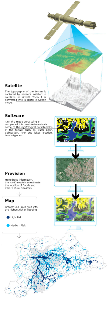
The HAND (Height Above the Nearest Drainage) Model is a hydrological tool developed to generate numerical terrain descriptors, utilizing satellite imagery for terrain analysis. Supports environmental and geographical studies by processing raster data with high precision.
//role
Sole developer, responsible for the UI using Qt Framework and data processing with GDAL.
//key highlights
- Developed a custom Qt-based interface for seamless user interaction, facilitating efficient terrain analysis and data visualization.
- Utilized GDAL to manipulate raster satellite images, enabling complex terrain modeling and accurate drainage mapping.
- Integrated EigenC++ for advanced matrix operations, improving computational performance in hydrological calculations.
- Connected with MySQL for efficient storage and retrieval of processed data, supporting large datasets.
//video
02
Scientific · Simulation
Wind Trek
Particle trajectory simulator using a Lagrangian algorithm for precise dynamics visualization.
C++
Qt
MySQL
Scientific · Simulation
Wind Trek
//overview
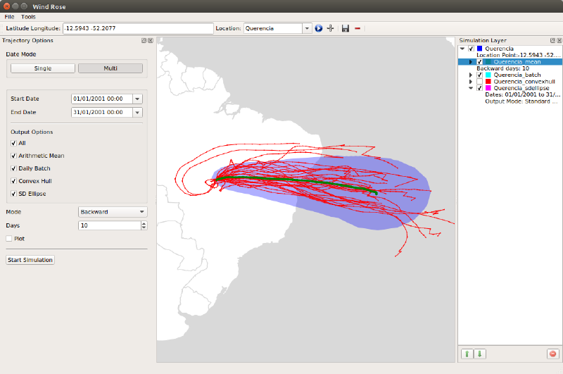
A particle simulator developed using a Lagrangian algorithm to track trajectory paths, providing insights into particle dynamics and behavior. Built for scientific research environments requiring high-precision visualization.
//role
Lead developer, responsible for the entire UI/UX using QGraphicsView and backend integration with MySQL.
//key highlights
- Built a custom Qt-based interface using QGraphicsView components, enabling interactive and responsive visualization of particle trajectories.
- Implemented a Lagrangian algorithm for accurate particle tracking and simulation.
- Integrated MySQL for storing and retrieving simulation data, enhancing data persistence and analysis.
//video
03
Hardware · Systems
Remote TLE Observation
Pan-tilt camera system for capturing Transient Luminous Events with custom PCB hardware.
C
Arduino
Python
PHP
Bash
Hardware · Systems
Remote TLE Observation
//overview
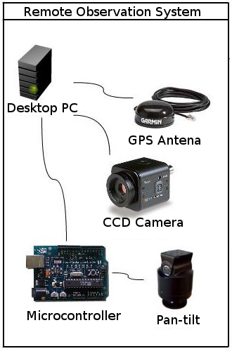
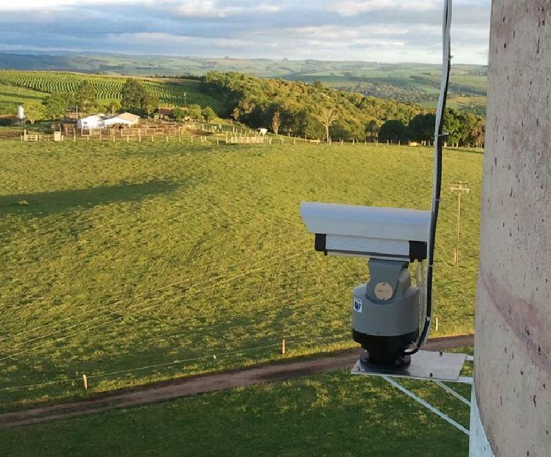
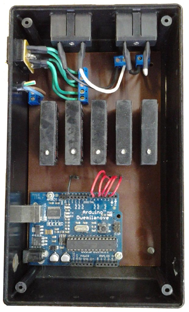
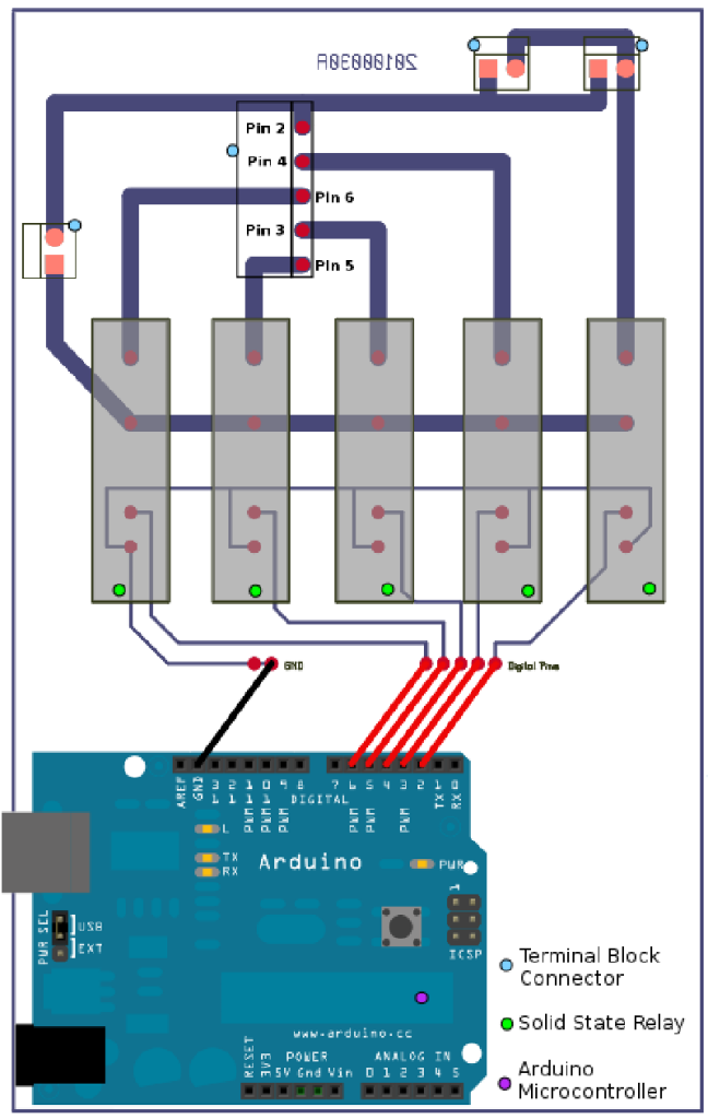
A remotely controlled camera setup with pan-tilt functionality designed to capture TLEs (Transient Luminous Events). Integrates hardware and software to create a responsive system capable of tracking and photographing atmospheric phenomena.
//role
Developer and system integrator, handling both hardware and software components to enable remote control and image capture.
//key highlights
- Designed and programmed a PCB and Arduino-based system for controlling camera orientation and movement, allowing precise tracking of TLEs.
- Developed a Web API using Python and PHP to enable remote control of the camera system, allowing for real-time adjustments and monitoring.
- Used Bash scripting for automation and system maintenance tasks, enhancing operational efficiency.
04
Web · Frontend
Website 4 Elements
Minimalistic website built from scratch, emphasising simplicity and ease of navigation.
ReactJS
Styled Components
// experience
Oct 2012 – Jul 2017
NPE — National Institute
for Space Research
C++ / Qt Developer & GIS Analyst
- Built a desktop application for raster data manipulation and scientific visualization, improving algorithm performance and usability.
- Architected GIS and remote sensing tools under senior research scientist supervision.
- Worked directly with end users to design coherent, intuitive application workflows.
- Designed the project website and logo, establishing a unified visual identity.
Mar 2008 – Feb 2012
NPE — National Institute
for Space Research
Matlab / Python / C Developer & GIS Analyst
- Developed Matlab scripts for raster and text data processing to support scientific researchers.
- Engineered a remote-controlled pan-tilt device using Arduino and solid-state relays.
- Designed and tested custom PCBs for scientific data collection instruments.
- Collaborated with weather station staff to install TLE-capturing devices for transient luminous events.
- Created GIS and remote sensing CLI tools in close collaboration with end users.